


GREAT BRAK RIVER – HISTORY
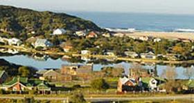
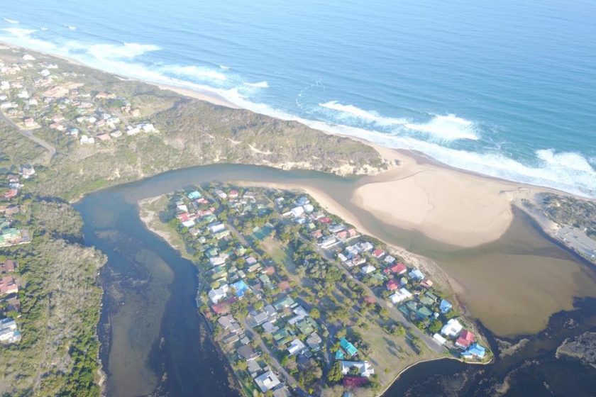
Great Brak River derives its name from the brackish taste of the water from the two Brak rivers – the lagoon mouth is divided into two sandy channels with a small island between them.
The town originated in 1859, when the tender for Keeper of the Toll Bridge at Great Brak River was awarded to Charles Searle, an English paper-mill hand who emigrated to the Cape from Surrey with his wife and four children. His elder brother Richard was originally a laborer and emigrated to South Africa to work for the Central Road Board in 1850 following a sea voyage of 68 days. At that stage the toll bridge consisted of a toll-house, a small boarding house called Ferreira’s and a farmhouse on the Mossel Bay side of the river.
The Searle family prospered and soon their business expanded to include shops, accommodation, a tannery, shoe-making and timber businesses in the village, which was in turn shaped by these enterprises. Their boarding house known was known as the Temperance Hotel, as the Searles were staunch abstainers from alcohol and expected everyone else in the village to follow suit. From the outset, therefore, they opposed the sale of liquor and, in time, Great Brak River became known in the neighborhood as “Prohibition Village”. The 1904 census indicated that Great Brak River had a population of 362.
https://www.gardenroute.com/great-brak-history_content_op_view_id_2962
Did you know?
‘The Legend of the Fat Tailed Sheep’.
This is the story of the enchanting travels of our Khoe People on their journey to South Africa which took place a long time before Bartholomew Dias rounded the Cape. Today Sheep and Wool production are very much a part of South Africa but do you know their history and that Great Brak River originally had a wool washery. The main story will be told in slide/picture format but there will also be exhibits on wool production (slavery, farming, shearing, spinning and knitting the finished product).
Fat tailed or fat-rumped sheep are so-named because they can store large amounts of fat in the tail and region of the rump. Fat-tailed sheep are now found mostly in the extreme environments in Africa, also the Middle East and parts of Asia. They grow wool, but are raised primarily for meat or milk production. Fat-tailed sheep comprise some twenty-five percent of the old world’s sheep population.
All wild sheep have thin tails, as our European sheep do. The fat tail is a feature humans created by breeding sheep to concentrate their subcutaneous fat in the tail. The purpose was convenience in harvesting fat for cooking. The fat was used extensively in medieval Arab and Persian cookery. The tail fat is still used in modern cookery, especially in countries such as Morocco. The wool from fat-tailed breeds is usually coarse and frequently has coloured fibres. Today it is used primarily for rug-making and other cottage-type industries. Bedouin women make rugs and blankets from the wool. Some of their handiwork can be purchased in the villages of Egypt. Shearing in Egypt is done once or twice a year with hand clippers.
Also in the news; the Great Brak River Museum has a coffee shop, “The Pelton Wheel”, where you can come and relax, enjoy a cup of tea or coffee and a pancake whilst selecting a pre-read book from our large selection.
Do you Know? The Great Brak River Museum is 38 Years Old on the 21st June 2017.
Become a FRIEND of the Great Brak River museum and enjoy our social get to-gethers and interesting programs.
To become a FRIEND besides receiving invitations to our evenings and outings you will receive copies of our monthly newsletter, the cost is R100.oo for twelve months.
Should you wish to receive copies of our monthly newsletter by post, the cost is R200.oo per annum (covers the cost of printing and postage).
We also accept business membership at R200.oo per annum. This helps your village museum with funding and in turn we will advertise your business several times a year as and when space is available at no extra cost.
 Your museum newsletter has been going nonstop for more than nine years on a monthly basis without a break, and it is circulated directly to more than 400 Friends and interested parties who in turn circulate it throughout South Africa and the world. Quite a record?
Our Bank account is FNB (First National Bank) at Mossel Bay
Great Brak River Museum Association
Branch number 210314
Account Number 62201449172
or drop into the museum at 13 Amy Searle Street,
week days between 8.30 am to 4.00 pm.
044-620-3338
May month, 2017, at the Great Brak River Museum will see several new displays:
History of Rugby in Great Brak River and Mossel Bay.
The KHOE Room has been updated with four new display boards.
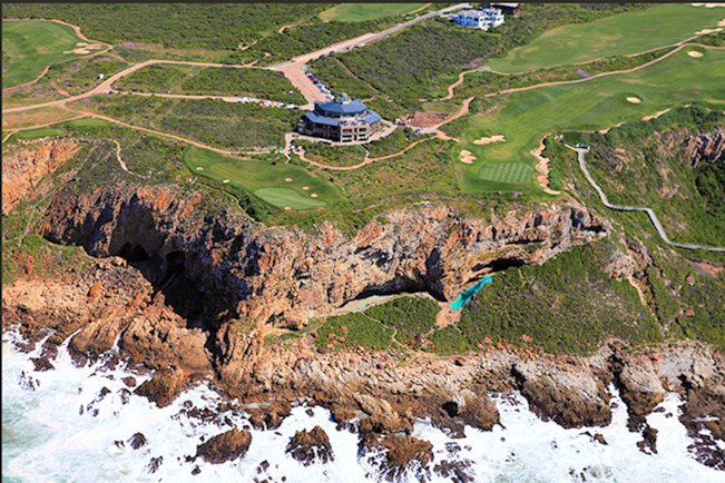
Then we have the story of the first tannery in the village and the people who lived in the dangerous kloof during times of tranquility and flood.
We also have, in the KHOE room, a new and up todate time line of events for the past 220,000 years. But what about Homo naledi?
Did you know that man has been living in Mossel Bay for at least One Million years?
The much earlier Provincial Heritage Cape St. Blaize Cave in Mossel Bay is an important archaeological site, and a popular point for whale and dolphin watching. It is situated in the cliffs below the Cape St Blaize Lighthouse.
The cave is significant for a number of reasons: George Leith excavated it in1888 (making it one of South Africa’s earliest archaeological excavations). More importantly, though, the cave has revealed middens laid down by man’s early ancestors during much of the middle stone age. Who the people were is yet to be determined. There is still much evidence to be unlocked and it is hoped that further excavations will be started in the near in the future.
After debating for decades, paleoanthropologists now agree there is enough genetic and fossil evidence to suggest that Homo sapiens evolved in Africa ca. 200,000–160,000 years ago. The caves at Pinnacle Point, nearby, have reviled much more evidence pertaining to an earlier time and this evidence stretches back 164,000 years. In December 2012, the provincial heritage resources authority Heritage Western Cape declared the Pinnacle Point group of caves a provincial heritage site in the terms of Section 27 of the National Heritage Resources Act.
According to research which Professor Curtis Marean and his team published in 2007, this is probably where the small, core population that gave rise to all humans alive today first began to exhibit significantly modern behaviour: the systematic harvesting of food from the sea, the use of complex bladelet technology, and the use of ochre for symboling.
Most of the evidence comes to an end some 40,000 years ago and then reappears about 12,000 years ago with the retreat of the last ice age. There is convincing evidence that the latter are the San or Bushman people.
The missing evidence from 40,000 years to 12,000 years ago lies buried under the sea which during this period was an exposed landmass extending up to 140 kilometres from present day Mossel Bay. Inland evidence is minimal as during this period, much of southern Africa was an extremely cold desert.
Modern human behaviour is thought to have begun in the period from about 200,000 years ago evidenced by findings in other cave centres where further extensive development took place.
In several areas along our coastal corridor, other caves reveal findings mainly dating from about 3,000 years ago to the pre-colonial age (i.e. pre-1488).
There is some debate on where the Khoe people came from. In archaeological terms, these earliest herders in southern Africa introduced sheep and pottery. Some archaeologists and linguists believe that the Khoe (people who also spoke a click language like the Bushman) lived much further north towards East Africa (Zambia, Tanzania). They have been found historically in the Kalahari, Caprivi, Southern Zimbabwe and parts of South Africa. They arrived in the Cape some 2,100 to 2,200 years ago.
The Western Cape was not originally home to the Bantu who originally came from West Africa around 4,000 years ago and who arrived in the northern Transvaal some 1,500 years ago.
.
Frequently-quoted words of writer and philosopher George Santayana – “those who cannot learn from history are doomed to repeat it”. Come and see the progress we have made.
·
From Thursday 4th of October 2012, the Great Brak River Museum has been hosting a new display on the history of the people of Great Brak River from the beginning of time. Additional pannels and information is being added from time to time.
Alongside, a corner of the new exhibition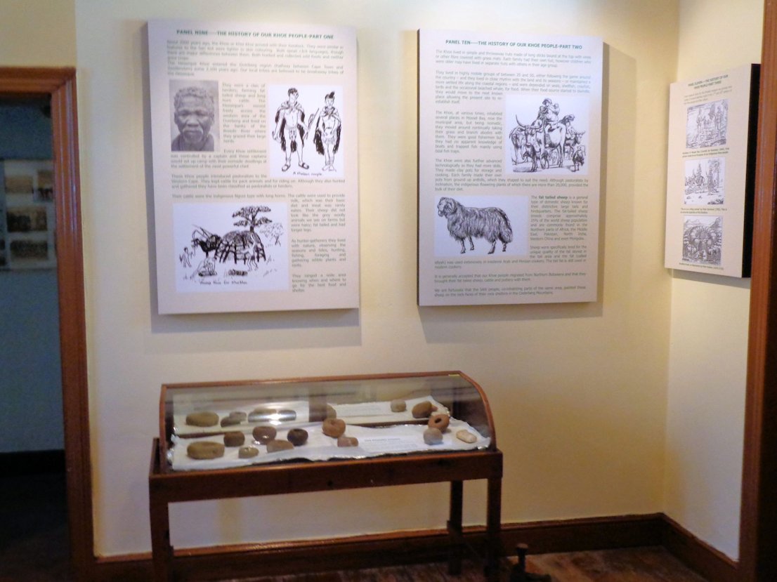
This exhibition is about the different peoples of the ‘Cape Corridor’ of the Western Cape who began their lives in our area; the ‘African’ or Modern Man who started out some 200,000 years ago to colonise the earth, the San who believe they were here from the beginning of time and for at least the past 12,000 years and our Khoe people who are the more recent arrivals.
Explore the history of ‘Modern Man’·in Mossel Bay’s coastal corrodor and see stone age tools that could be one million years old.
The museum is open from 8.30 am to 4.00 pm. during weekdays.
Phone your editor on 083-448-1966
If you have not received the latest issue of our ‘Heritage news letter’, please contact your editor.
History of the last major flooding in Great Brak River, June 2011.
With the advent of global warming it appears that cut-off lows over the African subcontinent are becoming more intensive (more rain). Great Brak River experienced its forth flood in as many years when on the morning of Wednesday the 8 th June, the Wolwedans dam which had been sitting at 88 % earlier in the week began to overflow. The sluices were opened when the water rose 1.70 metres above the dam wall. The recently repaired dam at Klein Brak River burst and various ‘Powertown’ residents had to be evacuated. The rain falling in the surrounding areas was highly intensive during a four hour period and the Sandhoogte road in Great Brak River was again flooded and damaged. The adjoining ‘Groenkloof’ retirement homes were temporally trapped by the rising waters. Further upstream the storm waters speed through ‘Greenhaven’ flooding houses and the ‘Pine Creek Caravan Park’. In this instance, the flooding was not as intensive as the preceding flood. Downstream, the Island and many of its houses were flooded when the escaping river waters could not satisfactorily breach the sand bar at the river mouth. This is the worst flood damage that the Island has ever experienced. The severe weather across the country was caused by a cut-off low pressure system which was caught between two external high pressure systems bordering to the east and west of Southern Africa. The rainfall whilst high throughout eight of our nine provinces was concentrated along the coastal area.
Managing our drinking water supply and infrastructure with weather alternating between extreme droughts and floods is proving a difficult task for the Mossel Bay municipality.
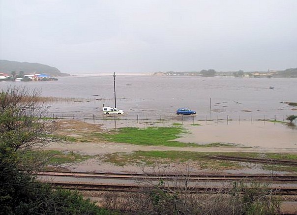
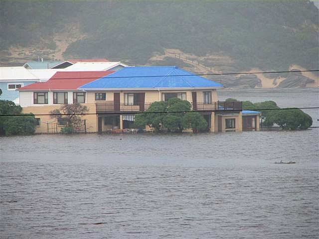
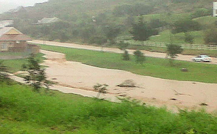
These photographs show Main Road to the Island underwater, Flooded houses on the Island and Sandhoogte Road which had been flooded, damaged and was then closed to ordinary traffic.
Also read the following article in the Great Brak Museum News letter of May 2014:
There is so much of Great Brak River’s past that we do not know hence the importance of documenting historic snippets as and when we find them.
The Tannery in Great Brak River & Other History Snippets. Your Editor
The Tannery
I came across a photograph taken in 1925 of the upper part of the tannery and tannery Kloof. I originally thought it had been ‘photo shopped’ or that it was a double exposure. Surely the tannery was never so high up the spruit. The main part of the tannery is much lower down and the houses this side of the kloof are long gone. Great Brak River Roads. Pauw Steyl sent me a copy of a postcard c 1904- 1910 to try and identify the original roads out of Great Brak River which the ‘post cart’ may have taken as it usually went straight up the hill. Thember 9 cottage shown in the right hand corner of the card on long street is no longer there and could have been washed away in one of the many floods Governor van de Graaff’s map compiled during the years 1785-94 shows one of the main wagon roads to the west as going through Great Brak at near the top of the estuary; the road then swings slightly to the north. When the Great Brak River mouth was closed as it often was, travellers usually crossed over the sand bar between the sea and the river mouth and then made their way inland over the dunes. This was a difficult route and many people were drowned. Van der Watt established the ‘intervening post station in 1812’ probably where the Wolwedans farm house in Amy Searle street is. In 1838 a J F Bunury decided to cross at the usual fording place higher up the river probably where the Charles Street bridge now is. No specific mention is made as to where they went up the hill. The farm ‘Voorburg’ was inhabited from about 1748. It had poor soil and covered a rather large area, see the map. The earliest date reference on this map is 1816 and as one can see there were many subsequent land divisions. There must have been numerous roads or rather tracks through Voorbrug (new name Voorburg) leading to the different farms. Many of these had their own farm tracks down to the river and through to the adjacent farm/s in ‘Dwarsweg’ or Crossroads which is above Glentana. The road on the far right of the postcard (starting off through Mossienes) is the first portion of what is now the Voorburg road and may have been one of the tracks used by the earlier pioneers to George before 1848 when the new main road was completed. The 1848 road (the extension to Charles street past the front of the old SPAR now Pick & Pay) is well off the postcard’s coverage and to the left and is what to day is still called Charles Street right up to the cross road junction in Sinksa Bridge, some miles away. In the early days there were some Coloured people’s houses on the rivers east back above Tannery Kloof (also off the postcard but seen on the photograph of the tannery) and the road on the left could have been their access road. It was probably also an old entry to the Voorburg road. The present Voorburg road seems to be a combination of the two roads shown on the postcard. Depending on the damage done during the ‘Great Fire’ in 1869, various tracks up the hill could have been used. Remember the Great Brak River top soil is of poor quality and they could have moved the road depending on the condition. Willie Searle’s house was built in 1913 and many wagon tracks coming from over the hill just in front of his house (on the right of Mossienes) were then visible indicating another possible route over the burg. The Google map below gives the routes of the roads today. That in the middle left being the Voorburg road and above top, the Charles Street extension.
Comments
I appreciate you for posting when you have the opportunity, Guess I'll just book mark this web
site.
Also visit my website: surviv io: https://surviv.online